Picture Instruments Smart GPS Sync Pro 2.0.10 for MacOS - FileCR
Free Download Picture Instruments Smart GPS Sync Pro 2.0.10 for MacOS Full Version - Transfer Geodata from one image to a batch images .
Free Download Picture Instruments Smart GPS Sync Pro 2.0.10 for MacOS Full Version - Transfer Geodata from one image to a batch images .
Free Download Picture Instruments Smart GPS Sync Pro full version standalone offline installer for macOS. It transfers the GPS data from one photo to any number of photos.
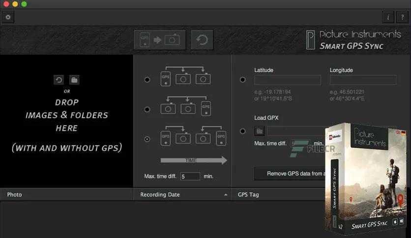
You don't want to do without GPS tags in your photos, but you also don't want to run a GPS logger all the time? If you take just one single photo containing GPS data with your smartphone, you can use "Smart GPS Sync" to transfer that GPS information to all other photos in your camera later.
If you have no photo with the correct GPS data at hand, you can also copy the longitude and latitude from Google Maps or Bing Maps into the corresponding fields and apply them to an entire batch of photos. It is beneficial for on-location and event photography, where not every photo is shot at a new location. This method is also beneficial if you occasionally want to add geodata to a photo.
On a photo trip, you can conveniently have a GPS logger running along (for instance, in a smartphone or an outdoor GPS device) and record a .gpx track. In the evening, you can load the .gpx file and all photos of the day into Smart GPS Sync, and the software will add the corresponding GPS information to every photo.*
Leave a comment
Your email address will not be published. Required fields are marked *