PIX4Dfields Download (Latest 2026) - FileCR
Free download PIX4Dfields 2.3.1 Latest full version - Mastering Precision Agriculture.
Free download PIX4Dfields 2.3.1 Latest full version - Mastering Precision Agriculture.


Free Download PIX4Dfields for Windows PC developed by Pix4D. This innovative software solution enables farmers, agronomists, and land managers to harness the potential of aerial imagery and data analysis for informed decision-making. This article will explore the features, benefits, and system requirements to help you understand how it can enhance your precision agriculture operations.
PIX4Dfields is cutting-edge software explicitly designed for agricultural applications. It leverages the capabilities of drone and satellite imagery to provide accurate and actionable insights about crop health, growth, and overall field conditions. By employing advanced image processing algorithms, PIX4Dfields enables users to generate detailed maps and 3D models of their fields, helping them identify potential issues, implement targeted interventions, and optimize resource allocation.
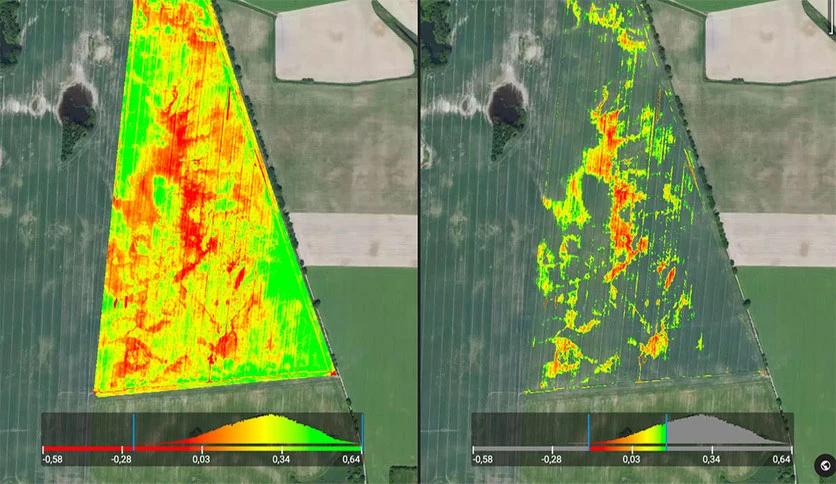
PIX4Dfields supports the analysis of multispectral imagery, allowing users to assess crop health and detect variations in vegetation vigor. Farmers can make informed decisions regarding irrigation, fertilization, and pest management by precisely mapping plant stress levels and identifying specific areas of concern, thereby optimizing crop productivity.
With PIX4Dfields, users can divide their fields into smaller zones based on characteristics such as crop type, health, and biomass. This zoning feature facilitates site-specific management, enabling farmers to tailor their interventions according to the unique requirements of each zone. It empowers them to implement precision practices like variable rate application of inputs, ultimately improving resource efficiency.
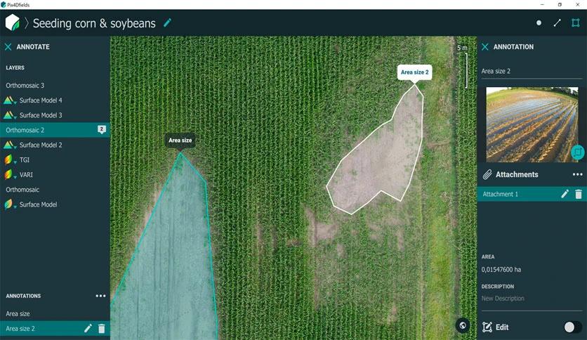
PIX4Dfields enables the accurate calculation of volumes for various agricultural purposes. Farmers can precisely measure stockpile volumes, estimate crop yields, and monitor soil erosion or deposition changes. This information aids in inventory management, crop planning, and assessing the effectiveness of soil conservation measures.
The software allows users to generate prescription maps, which serve as valuable guidance for the precise application of inputs. By incorporating data on soil properties, crop health, and specific field conditions, farmers can optimize the distribution of fertilizers, pesticides, and water resources. This targeted approach reduces costs, minimizes environmental impact, and maximizes the effectiveness of agricultural treatments.
To fully utilize the capabilities of PIX4Dfields, it is essential to ensure that your system meets the following requirements:
PIX4Dfields by Pix4D offers robust features and tools tailored specifically for precision agriculture. Farmers and agronomists can gain valuable insights into their fields by leveraging aerial imagery and advanced data analysis, leading to optimized decision-making and improved crop management practices. With its user-friendly interface and comprehensive functionality, PIX4Dfields is valuable for enhancing productivity, minimizing costs, and promoting sustainable agricultural practices. Ensure your system meets the requirements, and dive into the world of precision agriculture with PIX4Dfields today.
Leave a comment
Your email address will not be published. Required fields are marked *