GPXSee for MacOS Download (Latest 2026) - FileCR
Free download GPXSee for MacOS Latest offline Installer - GPS log file viewer and analyzer.
Free download GPXSee for MacOS Latest offline Installer - GPS log file viewer and analyzer.

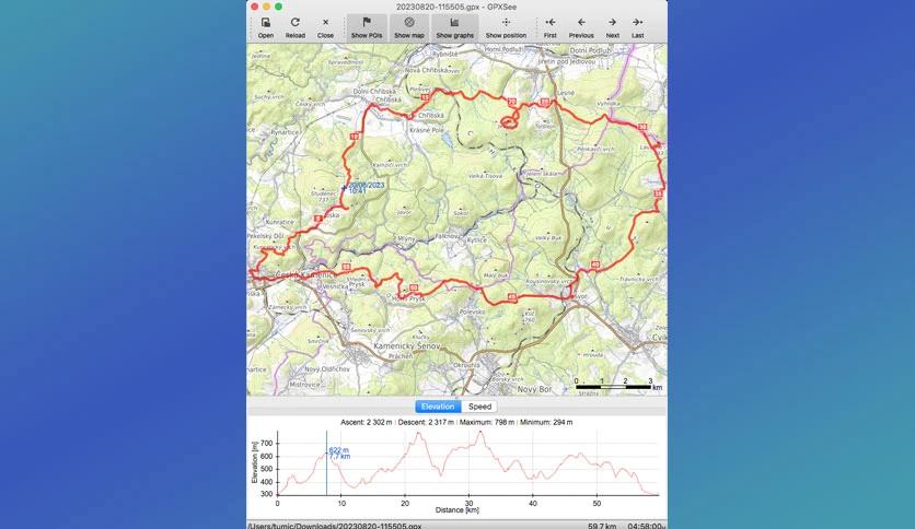
Free Download Martin Tuma GPXSee's latest standalone offline installer for macOS. It is a GPS log file viewer and analyzer that supports all standard GPS log file formats.
It is a lightweight and easy-to-use application that lets you view GPS tracks and waypoints on your macOS device. Whether planning a new route or reviewing past adventures, It provides detailed maps and statistics to enhance your outdoor experience. The software supports various map formats, including OpenStreetMap, Google Maps, and custom online maps, giving you flexibility in mapping preferences.
macOS 10.10 Yosemite or later
Q: Can I use GPXSee offline?
A: It is a standalone application that can be used offline, allowing you to view and analyze GPS tracks without an internet connection.
Q: Does It support other GPS file formats besides GPX?
A: Yes, It supports various GPS file formats, including TCX and KML, providing compatibility with a wide range of devices and applications.
Q: Can I customize the appearance of maps?
A: Yes, It allows you to customize the map display by choosing different map sources, adjusting colors, and adding overlays to suit your preferences.
Q: Is It suitable for beginners?
A: It is designed to be user-friendly and accessible to users of all experience levels, making it an excellent tool for beginners and experienced outdoor enthusiasts alike.
Leave a comment
Your email address will not be published. Required fields are marked *